
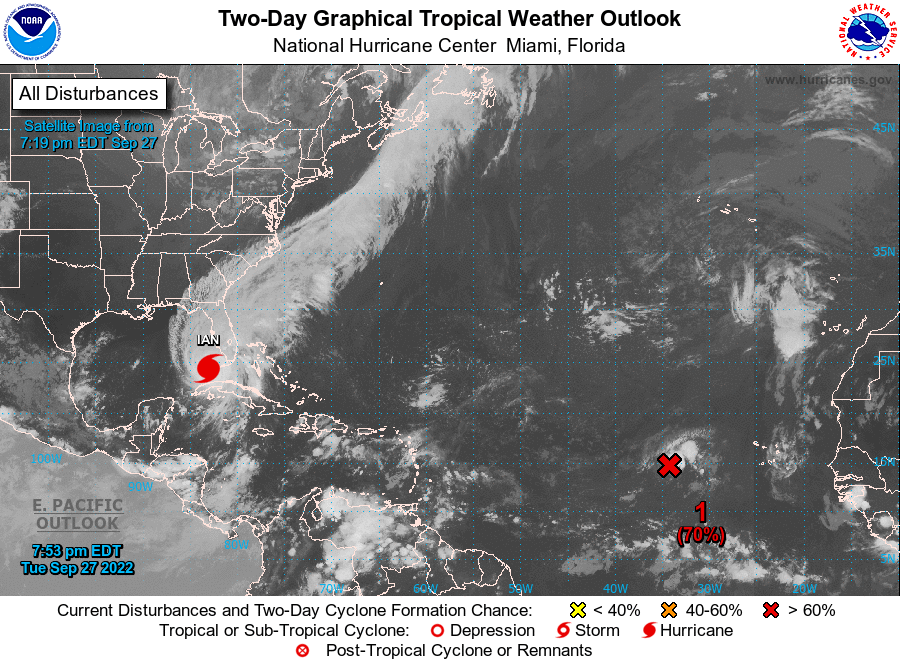
Meanwhile Hurricane Ian has turned to a Category 3 storm on Tuesday as it made landfall in Cuba on its path to Florida. Hurricane Ian has maximum sustained winds of 125 mph and is directional or moving mainly towards north at 12 mph.
Although the intensity and track about hurricane Ian is uncertain, it is forecasted to make landfall on Florida’s Gulf Coast or Panhandle by midday, Thursday.
Hurricane Ian : How To Know Your Zone of Evacuation
Jim Judge, Emergency Manager for Volusia County, and his counterparts make sure everyone knows what to do and when.
Meanwhile It is important to know what evacuation zone you live in. Firstly, Using the Florida Disaster ‘Know Your Zone’ Tool, simply enter an Address or alternatively use your phone’s location to find out your designated area to evacuate, in the event of a hurricane. Moreover, the emergency managers will be telling residents in each zone, whether to stay or evacuate, if there appears signs of the threat becoming real.
Evacuation is vital due to rise of water from the ocean, rivers or lakes or storm surge that cause flooding.
Likewise, when talking about hurricanes and evacuations, the saying goes “hide from wind, run from water.”
In summary, Jim Judge said, “You don’t have to go five miles away, you don’t go 100 miles away, you just move inland,”.
ALERT AND DANGERS
Presently Warnings and Watch are in-effect for –
• Warnings –
Hurricane Ian
Cuban provinces of Isla de Juventud, Pinar del Rio, and Artemisa.
Bonita Beach to the Anclote River, including Tampa Bay.
Dry Tortugas.
Storm Surge
Anclote River southward to Flamingo.
Tampa Bay.
Tropical Storm
Cuban provinces of La Habana, Mayabeque, and Matanzas.
Lower Florida Keys from Seven Mile Bridge westward to Key West.
Flamingo to Bonita Beach.
Suwannee River to the Anclote River.
Volusia/Brevard County Line south to Jupiter Inlet.
Lake Okeechobee.
• Watch –
Storm Surge
Florida Keys from the Card Sound Bridge westward to Key West.
Dry Tortugas.
Florida Bay.
Aucilla River to Anclote River.
Altamaha Sound to Flagler/Volusia County Line.
Saint Johns River.
Hurricane Ian
North of Anclote River to the Suwannee River.
Tropical Storm
North of the Suwannee River to Indian Pass.
Altamaha Sound to Volusia/Brevard County line.
Deerfield Beach to Jupiter Inlet.
What is a STORM SURGE ?
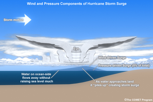
Along the coast, generally Storm Surge is often the greatest threat to life and property from a hurricane. Likewise, in the past, large death tolls have resulted from the rise of the ocean associated with many of the major hurricanes that have made landfall. For instance, hurricane Katrina (2005) is a prime example of the damage and devastation that can be caused by Storm Surge. At least 1500 persons lost their lives during Katrina and particularly many of those deaths occurred directly, or indirectly, as a result of Storm Surge.
Major Factor Impacting STORM SURGE
By the way, a Storm Surge is produced by water whilst being pushed towards the shore by the force of the winds moving cyclonically around the storm. Consequently, the impact on surge of the low pressure associated with intense storms is minimal in comparison to the water being forced toward the shore by the wind.