
Image Flickr.com
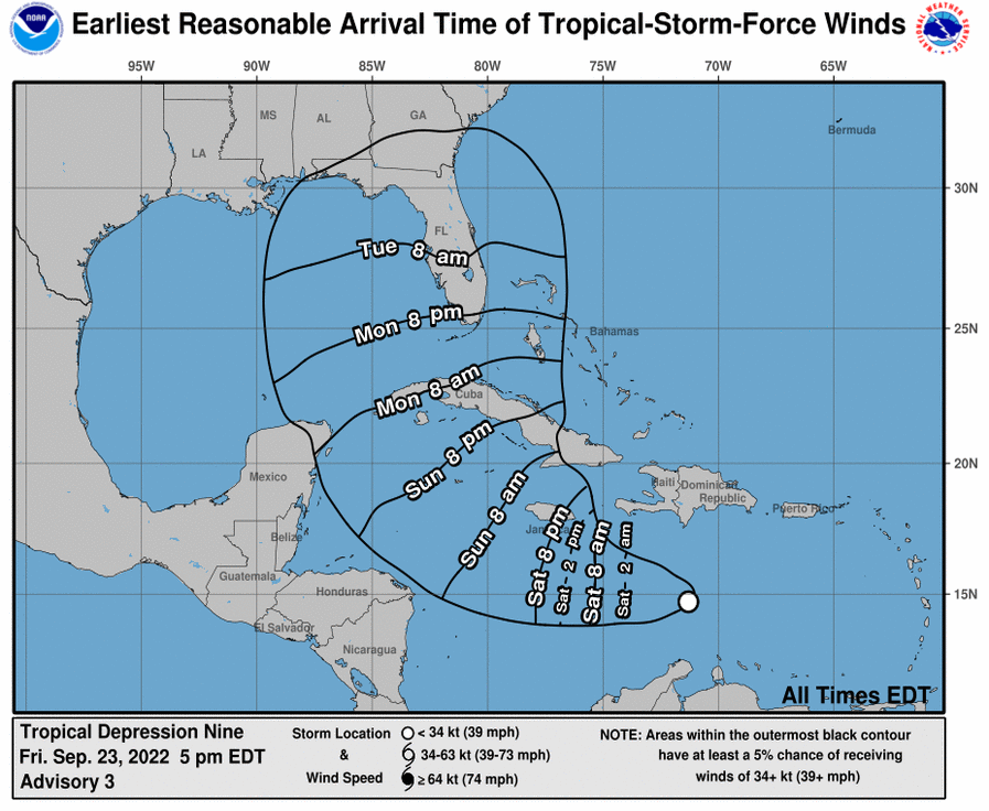
Tropical Depression Nine has formed in the Caribbean Sea and moving northwest at 13 MPH with maximum sustained winds of 35 mph. Hurricane threats langering large overhead.
The Hurricane Threat
There will be a slow intensification over the weekend that is projected to become Tropical Storm Hermine later today and grow into hurricane strength by Monday morning with its center south of Cuba near the Cayman Islands and Jamaica.
“We are watching the path, still not quite clear-cut, but it is aiming in the general direction of Florida sometime next week,” said Spectrum News 13 meteorologist Bryan Karrick. “So I’d spend the weekend getting your hurricane preps ready to go, maybe top off the gas tank, and get your generator ready, some bottled water and canned good as well as we watch the system next week.”
Hurricane Threat for Western Caribbean and Southeast U.S. including Florida.
Tropical Depression Nine may become a hurricane threat for the western Caribbean and Southeast U.S. next week, including Florida.
Tropical Depression Nine will likely drop heavy rainfall, flash flooding, and possible mudslides in Aruba, Bonaire and Curacao, with heavy rains in Jamaican and the Cayman Islands coming in the next few days.
Alerts and SOS Measures
The National Weather Service urged Florida residents and visitors to gather supplies and keep tracking the forecast.
The Seminole County Office of Emergency Management in Central Florida, has started its sandbag service and are preparing shelters in the event they’re needed.
Some guidelines to prepare for the worst –
Stock up supplies –
– Bottled water: One gallon of water per person per day.
– Canned food and soup, such as beans and chili
Can opener for the cans without the easy-open lids.
– Assemble a first-aid kit.
-Two weeks’ worth of prescription medications.
– Baby/children’s needs, such as formula and diapers.
– Flashlight and batteries.
– Battery-operated weather radio
Keep updated about the weather through –
– WESH.COM
If HURRICANE WATCH is issued by NOAA
– Prepare to bring inside anything else that can be picked up by the wind (trash cans, any lawn furniture, hanging decorations, plants, etc ).
– Prepare to cover all windows of your home. If shutters have not been installed, use precut plywood.
If HURRICANE WARNING is issued by NOAA
– Remaining indoors, in the center of your home, in a closet or bathroom without windows can be the best place during a tornado. Tornadoes can happen during a hurricane and after it passes over.
– Local official will advise about evacuation or moving to a shelter. Heed their advise.
– Evacuate your pets too. Even though you make arrangements to leave them behind, it can be life threatening for them. Make arrangements for them at friends or relatives or motels outside your immediate area.
– Enable emergency alerts on your smartphone to get emergency alerts.
Tropical Depression: A Prelude to Hurricane Formation
The Earth’s atmosphere is a dynamic system with various weather phenomena, including tropical depressions, which can evolve into powerful hurricanes. These low-pressure systems form over warm ocean waters, particularly in tropical regions, and can bring about devastating consequences. Let us explore the nature and characteristics of tropical depressions, their development into hurricanes, and the potential impacts they can have on affected regions.
What is a Tropical Depression leading to Hurricane?
A tropical depression is the initial stage in the life cycle of a tropical cyclone. It is characterized by a well-defined, low-pressure center accompanied by organized thunderstorm activity.
For a disturbance to be classified as a tropical depression, it must exhibit maximum sustained winds of up to 38 miles per hour (62 kilometers per hour). While they are less intense than hurricanes, tropical depressions possess the potential to intensify rapidly under favorable atmospheric conditions.
How is Tropical Depression formed before It Causes Hurricane to Occur?
Tropical depressions typically arise over warm ocean waters, where sea surface temperatures exceed 80 degrees Fahrenheit (27 degrees Celsius). These warm waters provide the necessary heat and moisture to fuel the system’s growth.
As moist air rises from the ocean’s surface, it condenses and forms towering cumulus clouds. The converging winds near the surface draw in more moisture, intensifying the thunderstorm activity and lowering the atmospheric pressure.
As the pressure drops, the system develops a defined center, becoming a tropical depression.
How does Tropical Depression Develop Into a Hurricane?
Given the right conditions, a tropical depression can progress into a more formidable tropical storm and, ultimately, a hurricane. Factors contributing to this transformation include warm ocean temperatures, low vertical wind shear (the change in wind direction and speed with height), and abundant moisture in the atmosphere. These conditions allow the system to continue its organization and strengthen.
If a tropical depression’s maximum sustained winds reach or exceed 39 miles per hour (63 kilometers per hour), it is officially classified as a tropical storm. At this stage, the system receives a name to aid in tracking and forecasting. As the storm further intensifies, sustained winds surpass 74 miles per hour (119 kilometers per hour), propelling it into hurricane status.
The intensity of a hurricane is classified using the Saffir-Simpson Hurricane Wind Scale, which ranges from Category 1 to Category 5, with Category 5 representing the most powerful storms.
Preparations Needed to Counter Impact of Tropical Depression causing Hurricane?
Tropical depressions can have significant impacts even before they develop into hurricanes. The primary concerns include heavy rainfall, strong winds, and storm surges. Heavy precipitation associated with tropical depressions can result in flash flooding, leading to property damage, infrastructure disruption, and potential loss of life. Strong winds, though not as intense as in hurricanes, can still cause damage to structures, power lines, and vegetation.
In regions prone to tropical depressions and hurricanes, it is crucial for residents to remain vigilant and prepared.
Early detection and monitoring through advanced meteorological systems provide valuable lead time for evacuation procedures, emergency response planning, and public safety initiatives.
By staying informed and following guidance from local authorities, individuals can minimize the risks associated with these powerful weather systems.
In a Nutshell
Tropical depressions mark the initial stage of a tropical cyclone’s life cycle and can rapidly evolve into powerful hurricanes. Understanding their formation process, development, and potential impacts is vital for safeguarding communities in vulnerable regions. With the advancement of technology and improved forecasting capabilities, scientists and meteorologists can better track, predict, and communicate the risks associated with these weather systems. Through proactive measures and preparedness, societies can mitigate the impact of tropical depressions and hurricanes, ensuring the safety and well-being of those in their path.